
Cork City centre is compact, varied and contains all the amenities for most people’s everyday needs. The City centre shops and facilities are within 15 minutes walk (green) for 22,530 residents, within 30 minutes walk (cyan) for 53,481 residents and 45 minutes walk, or 20 minutes cycling (pink) for 106,200 residents.
These residents are, equally, the consumer base of many of the businesses within Cork City centre, and the audience for appeals on footfall and invigorating activity in Cork.
I use the boundaries of Cork City, as defined at the time of the 2016 census, to count and plot how many can (and do!) walk, cycle, use public transport and live without cars or private motorised vehicles in Cork City. Links to the full CSO Small Area Population Statistics (SAPS) are included (and repeated in full at the end), as well as some excellent sources of information about the City, including the Pedestrian Cork Survey 2020.
(See also “Conserving accesible urban space” for a discussion on accessibility and sensory overload in Cork City).
As a first step, the active transport distance from the centre of Cork, and a location of the centre, need defining. I took Waterstones on Patrick Street as a centre – a highly recognizable bend in the road is easy to spot in maps, and it is the midpoint of Centre A and Centre B electoral districts. I assume most retail, health and leisure providers, and most other resources are distributed roughly equally around this point.
The highest resolution data, and smallest areas within national statistics, are contained in the Small Area Population Statistics (SAPS) and map down to Electoral Districts. There are 74 EDs in the 2016 SAPS with a mean population of just 1,700 people in each, which is a fine scale for mapping walking patterns.The most recent data available is from the 2016 Census, with Cork City as it was before the 2019 boundary changes. The next edition of the SAPS will be based on the 2021 census and available in 2021/22. The full (national) data is available from the CSO SAPS page. Map boundaries are available in many formats, including ESRI shapefiles, from the OSi National Statutory Boundaries, Electoral Divisions page.
(I use the statistics language R within RStudio and the Maptools package for calculation and map output).
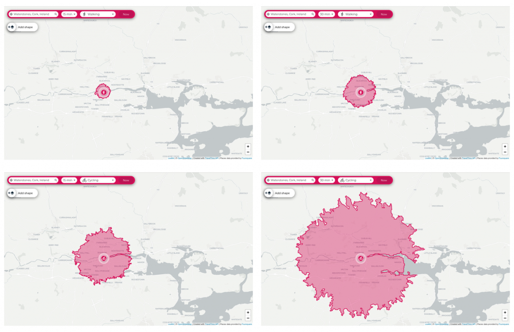
Approximate reachability of the city could be generated with a circular radius, assuming say 6 km/h average walking speed, or here with the TravelTime online calculator. From experience Cork City is far more reachable when travelling East-West than North-South, so these circular approximations could be improved.
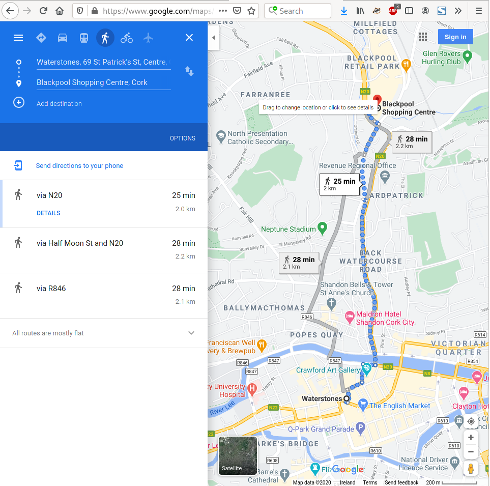
A more rigorous reachability is easy (if tedious) to calculate using Google Maps to calculate real routes with estimated walking or cycling times, plotting out a 15 or 30 minute extent. Mapping these over electoral districts I made a subjective judgement about whether ‘most’ of the properties in the district are within the extent or not within the extent. Note that there are very few electoral districts where the judgement is difficult – most are completely contained or completely excluded, presumably because most district boundaries are defined by large thoroughfares.
The walkable city
Cork City centre is within less than 15 minutes walk for 21,530 people, less than 30 minutes for 53,481 people and less than 45 minutes for 106,200 people – that includes 84% of the city population within a 45 minute walk or 20 minute cycle ride.
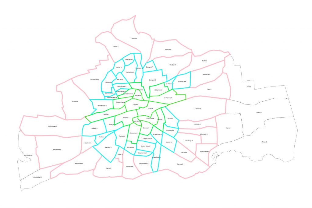
The City centre (green) contains most of the shopping, dental & medical, legal, nightlife and other facilities of Cork City. The 15-minute centre consists of Centre A, Centre B, City Hall A, Evergreen, Gillabbey A, Greenmount, Gurranebraher C, Mardyke, Shandon A, Shandon B, South Gate A, South Gate B, St. Patrick’s A, St. Patrick’s B and Sundays Well B. The population of the centre is 21,530 people.
The Inner (cyan) section of the City consists of Ballinlough A, Ballyphehane A, Blackpool A, Blackpool B, Churchfield, City Hall B, Fair Hill A, Fair Hill B, Farranferris A, Farranferris B, Farranferris C, Gillabbey B, Gillabbey C, Glasheen B, Glasheen C, Gurranebraher A, Gurranebraher B, Gurranebraher D, Gurranebraher E, Montenotte A, Pouladuff A, St. Patrick’s C, Sundays Well A, The Lough, Tramore A, Turners Cross A, Turners Cross B, Turners Cross C and Turners Cross D. The population of the Inner ring is another 31,951 people, a total of 53,481 people within the Inner extent and within a half-hour walk of Patrick Street.
The Outer (pink) section of the City consists of Ballinlough B, Ballinlough C, Ballyphehane B, Bishopstown A, Bishopstown C, Bishopstown E, Browningstown, Commons, Fair Hill C, Glasheen A, Knocknaheeny, Knockrea A, Knockrea B, Mayfield, Montenotte B, Pouladuff B, Shanakiel, The Glen A, The Glen B, Tivoli A, Togher A, Togher B, Tramore B and Tramore C. The population of the Outer ring is a further 52,719 people, a total of 106,200 people within the Outer extent and a 45 minute walk, or 20 minute cycle ride, of the City centre.
There remains a part of the City (as defined in 2016) that is not within a 45 minute walk, or 20 minute cycle ride, of the City centre. In the expanded 2019 boundaries, these districts might be better represented as within a shorter active journey from other retail centres. These are Bishopstown B, Bishopstown D, Mahon A, Mahon B, Mahon C and Tivoli B.
Active and public transport
Within Cork City centre, 13,116 people (39.4%) walk to work or school, 1,415 (4.3%) cycle and 3,896 (11.7%) take a bus to work or school. Walking is the most frequent commute. Active (walking & cycling) and public (bus & train) transport (55.9%) exceeds car use (33.2%).
(In the maps that follow, the percentage of population or household is displayed with a colour scale where 0%=Black, 25%=Blue, 50%=Gray, 75%=Red and 100%=Orange. Any blue-black area is below 50%, and any red-orange area is above 50%.)
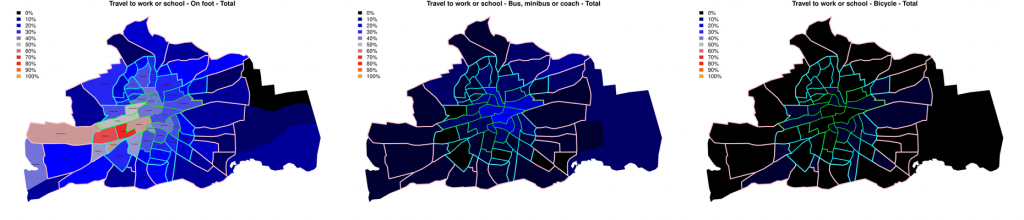
Walking: A total of 13,116 people (39.4% of the resident population) within the City centre – within the 30 minute walk extent – walk as their primary mode of transport to work or school. More than half the population in Gillabbey A, B and C, Glasheen B, Mardyke and Sundays Well B (the red areas in the leftmost map) walk to work. Walking is most frequent in the centre and the Western districts around UCC and CIT. The lowest proportion walking is 20.7% in Tramore A, which means at least one fifth of the population – across the entire City – walk as their primary mode of transport.
Bus: A total of 3,896 people (11.7% of the population) in the central (30 minute) area use a bus, minibus or coach for their primary transport to work or school. This exceeded 20% in Centre A and B, St Patrick’s A, Shandon A and South Gate A. Bus use is concentrated in the centre and the Eastern periphery, the blue areas in the central map.
Cycling: A total of 1,415 people (4.25% of the population) in the central (30 minute walk) area cycle to work or school. The highest frequencies of cycling rose to 8.2% in Turners Cross A and is higher than 7% across Ballinlough A, City Hall A and Turners Cross A. These areas tend to be more residential, but at the edge of the 30 minute walking extent, coloured blue on the rightmost map. For those who can cycle, it more than doubles the extent within reach on foot, which brings more than four times the area within reach – more than four times as many shops, businesses, markets and leisure activities, and greater opportunities for work and socialising.
Car transport
Walking is the most frequent form of commuting to work or school, 39.4% of all residents walk. The quality and widths of pavement, and the timing of pedestrian crossings, do not reflect this preferred mode of transport in the city.
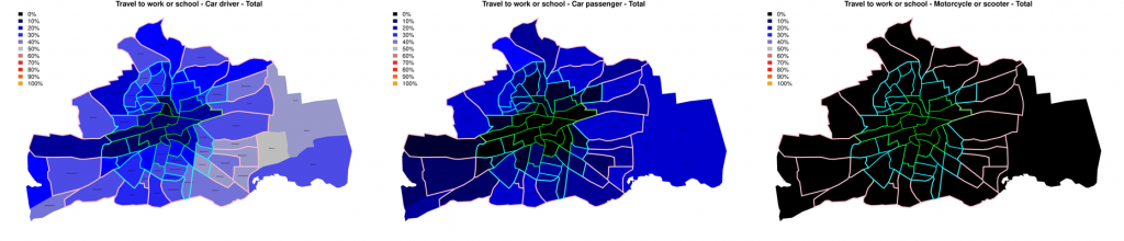
Cars: The use of cars as driver is the primary transport of 8,026 people (24.1% of the population) and as a passenger by a further 3,020 people (9.07% of the population) within the central, 30 minute area. Motorcycle and scooter use was rare (0.29% of the population).
Active, public and private transport
Active transport is the most frequent mode for most people in the City centre (43.7%), and combined active and public transport (55.9%) far exceed car use (33.2%).
Car (non)ownership
41% of Cork City households own no car within 30 minutes walk from the centre. A total of 21,769 people live in these 9,359 households with no car and less than 30 minutes walk from the centre.
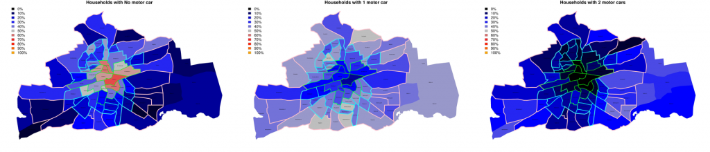
Car-free households: Most households in the City centre have no car. No-car households are most frequent in Centre A (67.9%) and over 50% across Centre A and B, Gilabbey B, Gurranebraher C, St Patrick’s A and B, Shandon A and B and South Gate A and B. These are the red central areas in the leftmost map above. Car-free households are most concentrated at the centre, but extend well out tot the peripheries of the City – the lowest frequency of car-free households is still as high as 19% in Ballinlough A.
Car ownership: Cars are rare in the centre, with just 18.6% of households owning 1 car in Centre A, and 1.46% 2-car households. Car ownership increases away from the centre, only becoming a majority in the furthest districts. The ownership of 1 car rises to 53% in Fairhill A and 51.3% in Turners Cross C. Two-car households are almost absent in the City centre, below 5% in Centre A and B, Shandon A and B and South Gate A. The highest frequency of 2-car households is in Ballinlough A at 25.7%.
Discussion
The Cork City population contains 53 thousand people within a 15 minute walk of the centre, or each other, and a total of 106 thousand within a 45 minute walk or 20 minute cycle ride of the centre. Almost the entirety of Cork City could function without personal, motorised transport for the majority of daily needs.
However, despite this large base of consumers, service users and audiences, Cork City seems to be overwhelmingly designed for motorised vehicles, for through traffic and to prioritise cars over people at junctions, crossings and the allocation of public space. Even recent ‘pedestrianisation’ schemes have been accompanied by parking, for people to drive to a place where they can walk or cycle.
Some aspects of active transport (such as segregated cycle lanes, or shared paths) exclude disabled people through the failure to add dished kerbs, the speed of cycles on paths and the addition of excessive traffic calming barriers (such as kissing gates and cobbles). Accessiblity should be foremost and central in every transport decision.
Disclaimer
I do not hold a vehicle licence, have never driven a car in my life, and have Asperger syndrome with a strong aversion to crowded public spaces. These undoubtedly influence my view that we should not devote 30% of the entire City surface area to cars, roads, parking and other forms of car-dependency.
Further reading
- Pedestrian Cork Survey 2020, one of the first efforts to understand pedestrian experiences in Cork from the perspective of road users. This community-led study was conducted in collaboration with the School of Applied Psychology, University College Cork.
- Cork City Profile 2018, A statistical and geographical profile of Cork City Local Authority area focused on Health and Social Inclusion.
- Cork City Development Plan 2022-2028, particularly:
“4. Shaping the Structure of the City” (“the delivery of walkable city neighbourhoods and urban towns that are highly accessible by public transport”)
“8. A Connected City” (“all journeys begin and end in walking regardless of other modes used”, and a focus on “short journeys of 2-3km” or around 15-30 minutes), and
“12. Green Infrastructure, Open Space and Recreation” (“Proposed greenways, the Lee2Sea and Euro Velo, are opportunities to allow people to walk, jog or cycle to and from work, school, shops and for recreation” – an unfortunate relegation of transport into a section on leisure). - Central Statistic Office (CSO) Census 2016 Small Area Population Statistics (SAPS), containing Electoral Division (ED) level demographic data from the most recent census of population.
- Ordnance Survey Ireland (OSI) Electoral Divisions Statutory Boundaries mapping data in shapefile and other formats compatible with various statistical mapping software.