As the prospect grows closer of a continuous cycle and walking route from the Inniscarra Dam to the harbour, this post assesses how many people and schools are within a car-free catchment area around the route. Two boundaries are displayed, a 2 km zone in which most people will be within a 15-minute walk and a 6 km zone in which most people are within a 15-minute cycle ride of the route. The number of post-primary schools and total pupil roll are separately counted.
These figures matter greatly because car park provision will be immediately raised, with the potential to induce additional motorised traffic to and around the route. In reality, large numbers of people, Bed & Breakfast, hostels and restaurants already lie directly on this resource, with large volumes of existing on-street and business parking space.
- The proposed Lee to Sea route provides 46 km of mixed woodland, lake, river and seaside greenway, with an elevation range of just 45 m;
- 157,000 people live within 2 km of the route and 229,000 within 6 km of the route – most could walk or cycle from home within 15 minutes;
- 60 primary schools with 16,922 pupils lie within 2km and 82 primary schools with 24,012 within 6km;
- 34 secondary schools with a total of 16,072 pupils lie within 2 km of the Lee to Sea route, and further 3 schools (Scoil Mhuire, St Aidan’s Community College and Douglas Community School) with a further 1,711 pupils lie within 6 km of the route;
- The route directly connects 37 of Cork County’s 85 secondary schools, with one another, and with the city and sea;
- 19 hotels offering 2,212 rooms lie within 2km of the route.
| Within 2km | Within 6km | In Cork City + County | |
|---|---|---|---|
| Residents | 157,356 | 228,731 | 417,211 |
| At Work | 65,439 | 97,103 | 179,890 |
| Primary schools | 60 | 82 | 342 |
| Primary pupils | 16,922 | 24,012 | 63,574 |
| Secondary schools | 34 | 37 | 84 |
| Secondary pupils | 16,072 | 17,783 | 42,893 |
| Hotels | 19 | 23 | 49 |
| Hotel rooms | 2,212 | 2,538 | >3,943 |
All analysis was performed with open source software using publicly available data, and all software and data sources are provided in the links at the end – also annotated R code used to generate these outputs. The technical description may be a helpful tutorial in using public data and mapping sources. This analysis was proposed by Orla Burke and Pedestrian Cork.
The Lee to Sea Greenway

The Lee to Sea route is set out on the project website, proposing a 45 km route for walkers, runners, leisure and commuting cyclists. Long stretches of the route are close to sea level and essentially flat and potentially extremely accessible to all. The route and rationale are descrbed in a detailed proposal document.
The Lee to Sea Greenway has many prominent supporters, including Cork Cycling Campaign.
Aims
The aims of this analysis were to collect and combine freely available public data and maps of the route of the proposed Lee to Sea route in order to determine how many people live within a reasonable active travel distance of the route. These were chosen as 2 km on foot and 6 km by bicycle, with most people within these regions able to travel to the route in 15 minutes or so.
In addition, the locations of all secondary schools were plotted to determine which schools lie within the two zones, and the total pupil roll with active travel access to the greenway.
Key outcomes
People
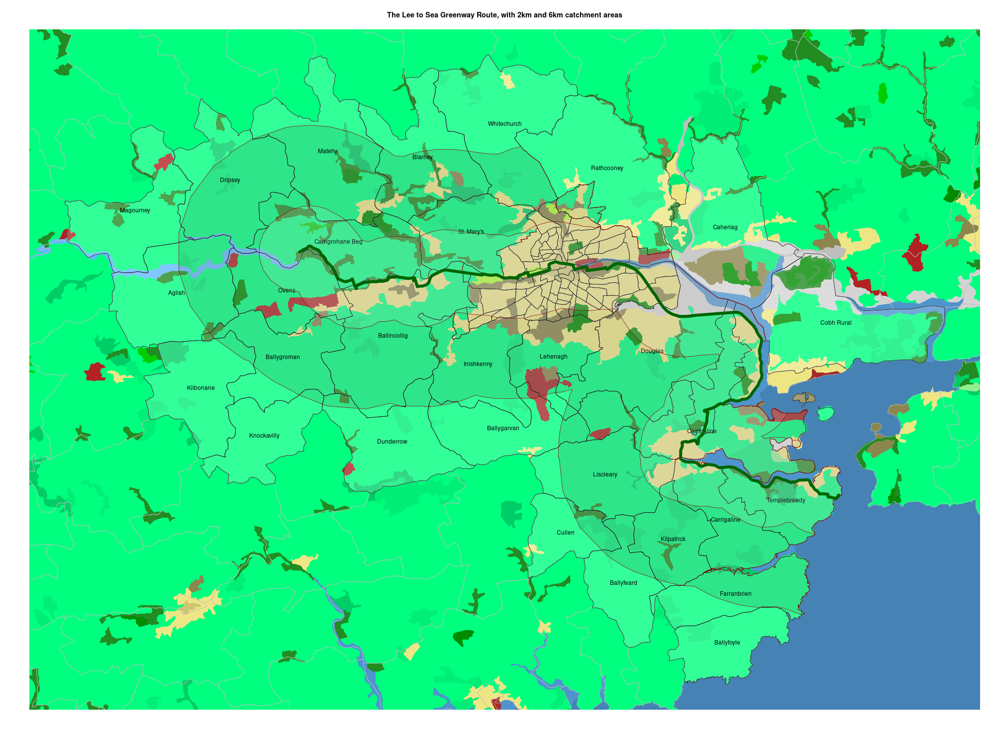
The route passes within 18 Electoral Divisions where between 40% and 100% of the land area of each ED lies within 2 km of the route, and between 79% and 100% within 6 km. A total of 93 EDs contain some land within 2 km (between 2% and 100%), and a further contain some land within 6km (between 1% and 100%).
Note that several EDs, while within 6km, are on the far side of the Lee with no crossing allowing a direct connection to the route. The populations of Caherlag, Carrigtohill, Cobh Rural, Cobh Urban, Corkbeg, Inch, Rathcooney and Riverstown were excluded from totals, although some people may find the river ferry or other access feasible.
The table below lists the total population resident in each ED, the percentage of land within 2 km and 6 km and (assuming even population density) and estimate of the number of people within walking and cycling distance of the route.
| Electroral Division | Population | Within 2km | Walkable population | Within 6km | Cyclable population |
| Carrigrohane Beg | 1499 | 76% | 1137 | 100% | 1499 |
| Ballincollig | 18621 | 43% | 7966 | 98% | 18199 |
| Bishopstown | 364 | 40% | 146 | 100% | 364 |
| Bishopstown A | 2223 | 100% | 2222 | 100% | 2222 |
| Mardyke | 840 | 100% | 840 | 100% | 840 |
| Centre B | 2117 | 100% | 2117 | 100% | 2117 |
| Centre A | 868 | 100% | 868 | 100% | 868 |
| City Hall A | 833 | 100% | 833 | 100% | 833 |
| City Hall B | 1191 | 100% | 1191 | 100% | 1191 |
| Knockrea B | 1047 | 100% | 1047 | 100% | 1047 |
| Mahon A | 5066 | 100% | 5066 | 100% | 5066 |
| Douglas | 21041 | 46% | 9748 | 99% | 20872 |
| Mahon B | 4937 | 99% | 4890 | 100% | 4937 |
| Carrigaline | 12118 | 72% | 8678 | 100% | 12118 |
| Monkstown Rural | 1086 | 100% | 1084 | 100% | 1086 |
| Carrigaline | 2462 | 43% | 1050 | 100% | 2462 |
| Monkstown Urban | 5219 | 100% | 5219 | 100% | 5219 |
| Templebreedy | 3778 | 90% | 3398 | 100% | 3778 |
| Ballygroman | 1673 | 1% | 21 | 79% | 1327 |
| Ovens | 2342 | 45% | 1062 | 100% | 2342 |
| Matehy | 3017 | 3% | 78 | 68% | 2064 |
| Bishopstown B | 1934 | 86% | 1657 | 100% | 1934 |
| Inishkenny | 5650 | 3% | 164 | 88% | 4989 |
| Bishopstown D | 1492 | 20% | 295 | 100% | 1492 |
| St. Mary’s | 5538 | 41% | 2253 | 100% | 5537 |
| Bishopstown C | 4925 | 100% | 4925 | 100% | 4925 |
| Shanakiel | 3638 | 100% | 3637 | 100% | 3637 |
| Bishopstown E | 3253 | 96% | 3122 | 100% | 3253 |
| Glasheen A | 813 | 100% | 813 | 100% | 813 |
| Gillabbey C | 2198 | 100% | 2198 | 100% | 2198 |
| Knocknaheeny | 4044 | 100% | 4043 | 100% | 4043 |
| Sundays Well A | 699 | 100% | 699 | 100% | 699 |
| Glasheen B | 716 | 100% | 716 | 100% | 716 |
| Glasheen C | 2733 | 100% | 2733 | 100% | 2733 |
| Togher A | 2064 | 62% | 1284 | 100% | 2064 |
| Churchfield | 1577 | 100% | 1577 | 100% | 1577 |
| Gurranebraher A | 769 | 100% | 769 | 100% | 769 |
| Gillabbey B | 1103 | 100% | 1103 | 100% | 1103 |
| Gurranebraher B | 588 | 100% | 588 | 100% | 588 |
| Fair Hill C | 3610 | 45% | 1641 | 100% | 3609 |
| Fair Hill B | 746 | 100% | 746 | 100% | 746 |
| Togher B | 701 | 100% | 701 | 100% | 701 |
| Fair Hill A | 714 | 100% | 714 | 100% | 714 |
| Sundays Well B | 892 | 100% | 892 | 100% | 892 |
| Gurranebraher E | 1143 | 100% | 1143 | 100% | 1143 |
| The Lough | 1623 | 100% | 1623 | 100% | 1623 |
| Gurranebraher D | 944 | 100% | 944 | 100% | 944 |
| Gillabbey A | 2418 | 100% | 2418 | 100% | 2418 |
| Gurranebraher C | 1053 | 100% | 1053 | 100% | 1053 |
| Farranferris B | 928 | 100% | 928 | 100% | 928 |
| Pouladuff B | 1675 | 40% | 674 | 100% | 1675 |
| Pouladuff A | 723 | 100% | 723 | 100% | 723 |
| Farranferris C | 607 | 100% | 607 | 100% | 607 |
| Greenmount | 2066 | 100% | 2066 | 100% | 2066 |
| Commons | 963 | 21% | 197 | 100% | 962 |
| South Gate B | 956 | 100% | 956 | 100% | 956 |
| Shandon B | 1401 | 100% | 1401 | 100% | 1401 |
| Farranferris A | 2044 | 100% | 2044 | 100% | 2044 |
| Shandon A | 1743 | 100% | 1743 | 100% | 1743 |
| Ballyphehane A | 662 | 100% | 662 | 100% | 662 |
| Ballyphehane B | 806 | 42% | 337 | 100% | 806 |
| Turners Cross C | 773 | 100% | 773 | 100% | 773 |
| Evergreen | 1407 | 100% | 1407 | 100% | 1407 |
| Turners Cross B | 1196 | 100% | 1196 | 100% | 1196 |
| South Gate A | 2163 | 100% | 2163 | 100% | 2163 |
| Blackpool A | 690 | 100% | 690 | 100% | 690 |
| Blackpool B | 2185 | 100% | 2185 | 100% | 2185 |
| Turners Cross D | 471 | 69% | 323 | 100% | 471 |
| Turners Cross A | 817 | 100% | 817 | 100% | 817 |
| St. Patrick’s B | 1162 | 100% | 1162 | 100% | 1162 |
| St. Patrick’s A | 1611 | 100% | 1611 | 100% | 1611 |
| The Glen B | 3699 | 40% | 1478 | 100% | 3698 |
| Tramore A | 793 | 100% | 793 | 100% | 793 |
| St. Patrick’s C | 856 | 100% | 856 | 100% | 856 |
| Ballinlough A | 786 | 100% | 786 | 100% | 786 |
| The Glen A | 2466 | 99% | 2450 | 100% | 2466 |
| Tramore C | 2966 | 41% | 1211 | 100% | 2966 |
| Montenotte A | 1676 | 100% | 1676 | 100% | 1676 |
| Tramore B | 1039 | 100% | 1039 | 100% | 1039 |
| Ballinlough B | 1757 | 100% | 1757 | 100% | 1757 |
| Knockrea A | 1476 | 100% | 1476 | 100% | 1476 |
| Liscleary | 4641 | 11% | 498 | 87% | 4049 |
| Rathcooney | 8574 | 0% | 0 | 0% | 0 |
| Ballinlough C | 1474 | 100% | 1474 | 100% | 1474 |
| Browningstown | 1044 | 96% | 1000 | 100% | 1044 |
| Mayfield | 2932 | 100% | 2932 | 100% | 2932 |
| Montenotte B | 2437 | 100% | 2437 | 100% | 2437 |
| Tivoli A | 1667 | 100% | 1667 | 100% | 1667 |
| Mahon C | 3272 | 100% | 3272 | 100% | 3272 |
| Tivoli B | 2756 | 100% | 2756 | 100% | 2756 |
| Kilpatrick | 526 | 4% | 21 | 99% | 519 |
| Caherlag | 7481 | 0% | 0 | 0% | 0 |
| Cobh Rural | 8353 | 0% | 0 | 0% | 0 |
| Magourney | 1049 | 0% | 0 | 1% | 11 |
| Aglish | 1453 | 0% | 0 | 39% | 573 |
| Kilbonane | 1267 | 0% | 0 | 6% | 81 |
| Dripsey | 1495 | 0% | 0 | 71% | 1068 |
| Knockavilly | 458 | 0% | 0 | 4% | 16 |
| Dunderrow | 1656 | 0% | 0 | 12% | 197 |
| Blarney | 5607 | 0% | 0 | 60% | 3361 |
| Ballygarvan | 1787 | 0% | 0 | 14% | 253 |
| Whitechurch | 3000 | 0% | 0 | 27% | 802 |
| Lehenagh | 10323 | 0% | 0 | 94% | 9749 |
| Cullen | 495 | 0% | 0 | 25% | 121 |
| Ballyfeard | 374 | 0% | 0 | 25% | 92 |
| Ballyfoyle | 362 | 0% | 0 | 0% | 0 |
| Farranbrien | 540 | 0% | 0 | 62% | 332 |
Schools and pupils
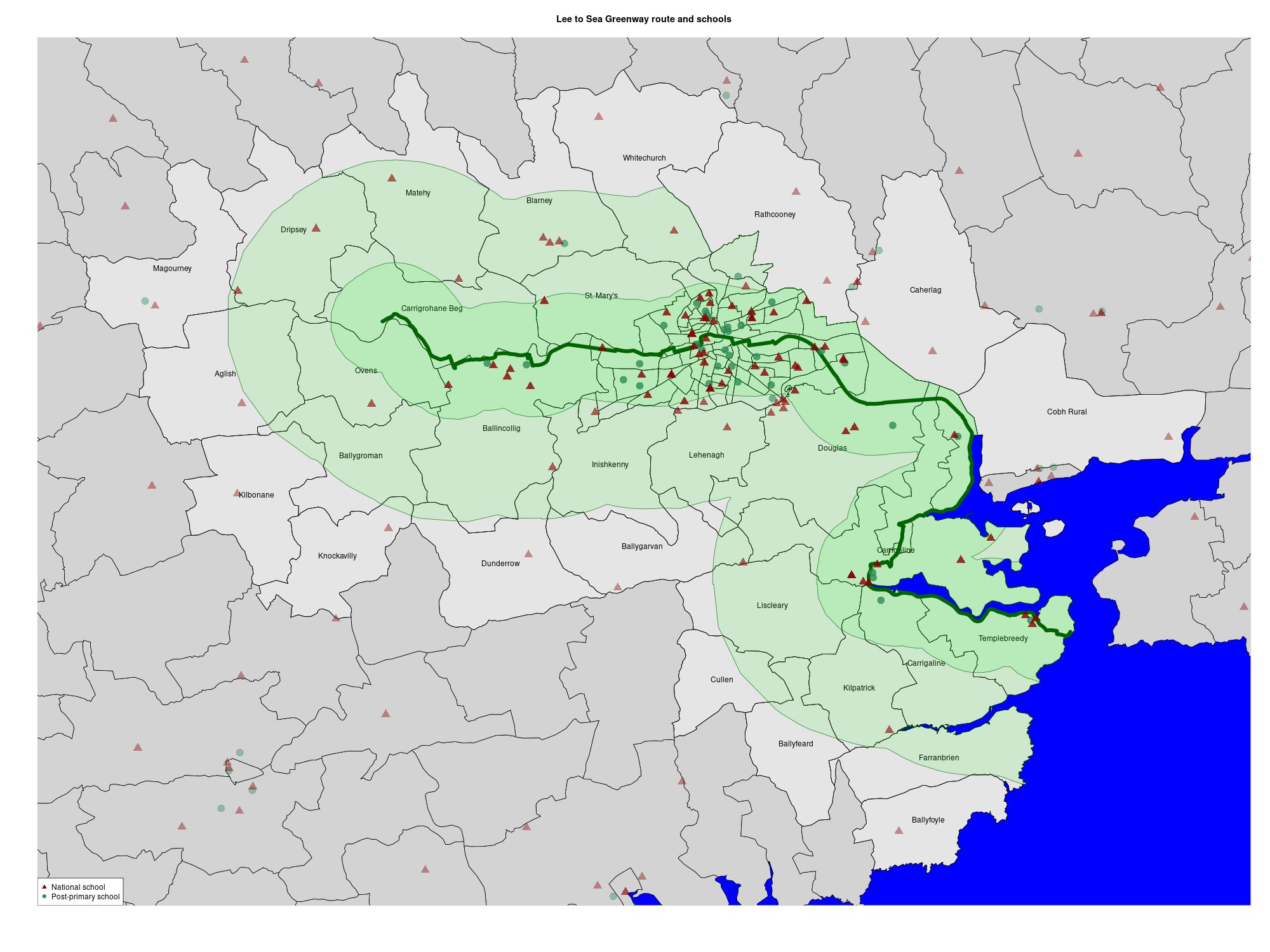
34 secondary schools lie on the route, within a distance of 2km, and a further 3 schools within 6 km. The total pupil roll is 16,072 pupils within walking distance of the route, and a further 1,711 pupils within 6 km.
The route connects, within 2 km, all of: Ashton School, Ballincollig Community School, Bishopstown Community School, Carrigaline Community School, Christ King Girls’ Secondary School, Christian Brothers College, Coláiste An Spioraid Naoimh, Coláiste Choilm, Coláiste Chríost Rí, Coláiste Daibhéid, Coláiste Éamann Rís, Colaiste Muire, Cork College Of Commerce, Cork Educate Together Secondary School, Edmund Rice College, Gaelcholáiste Charraig Ui Leighin, Gaelcholáiste Mhuire, Mayfield Community School, Mount Mercy College, Nagle Community College, North Monastery Secondary School, North Presentation Secondary School, Presentation Brothers College, Presentation Secondary School, Regina Mundi College, Scoil Mhuire, St Aloysius School, St Francis Capuchin College, St Patricks College, St Peter’s Community School, St Vincent’s Secondary School, St. Angela’s College, Terence Mac Swiney Community College and Ursuline Secondary School. Within 6 km are: Douglas Community School, Scoil Mhuire gan Smal and St Aidan’s Community College.
The route lies within 2 km of 60 primary schools with 16,922 pupils and within 6 km of 88 primary schools with 24,012 pupils.
Hotels

There are 19 hotels offering 2,212 rooms lying within 2 km of the proposed route, and 23 hotels offering 2,538 rooms within 6 km. This is proposal that offers an attraction to almost every hotel in Cork City and a substantial proportion of all the hotels in Cork County.
Commuters
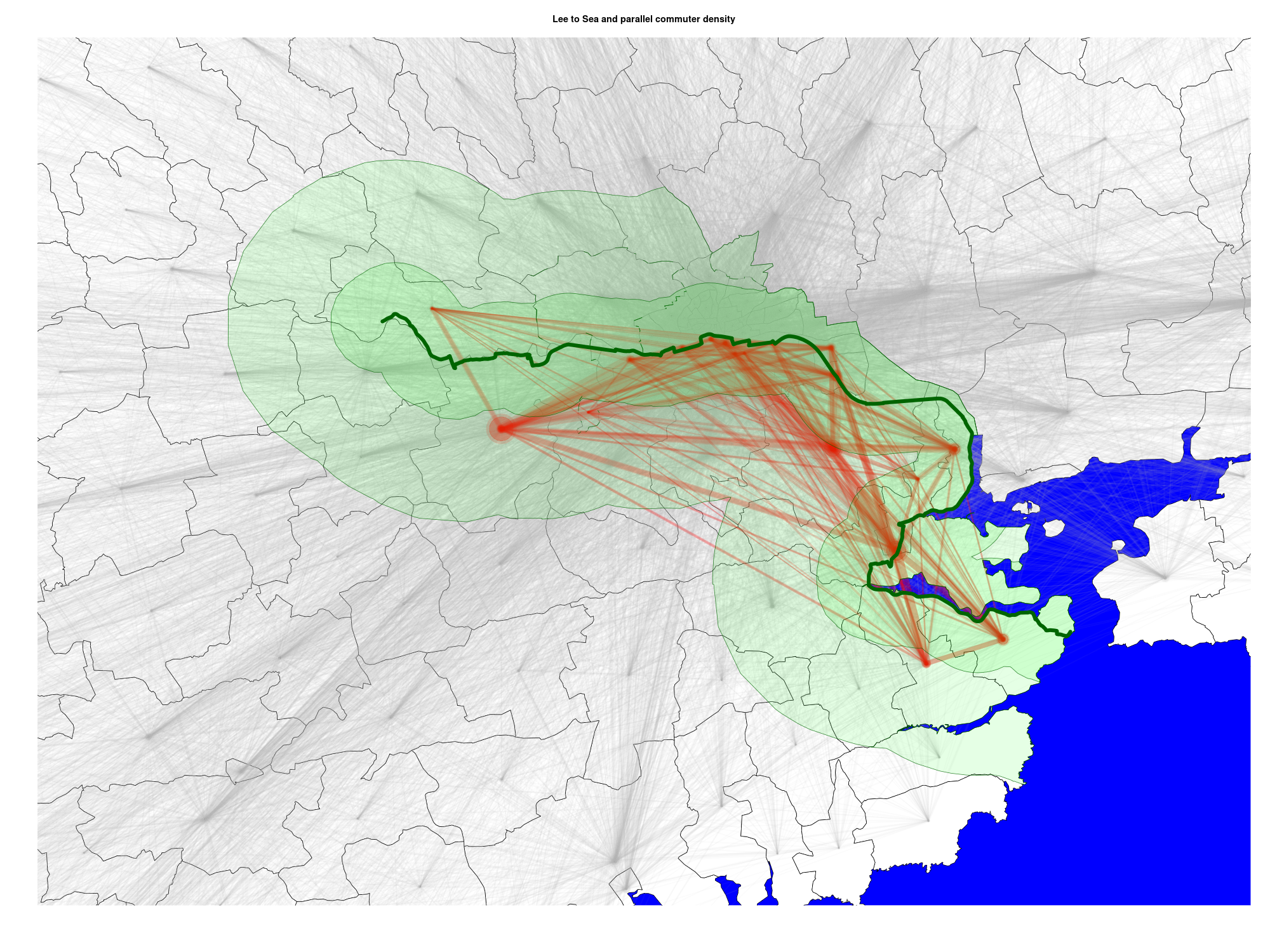
There are 29,245 commuters who start or end their journey in the Electoral Divisions through which the greenway passes, and 17,608 of these journeys both begin and end in EDs on the greenway. These journeys are parallel to the proposed route, and potentially represent converts to walking or cycle commuting on the greenway. The map above visualizes all the journeys in Cork City and County with these these 17,608 journeys highlighted in red, showing the 2k and 6km radius around the greenway.
For context 110,632 commuters work or learn in Cork City, 46,011 of whom live and commute within the city and 64,621 who commute into the city from elsewhere. The 17,608 who commute along the path of the greenway represent a large proportion of all commuters, and a huge potential for growth in active transport if their journeys could be safely made on foot or cycle.
Technical details
The maps and table above were produced using the statistical language R and its spatial geography packages rgeos and rgdal – these are directly available in Linux or from package archives for Windows and Mac operating systems.
The route of the greenway was calculated by Google Maps and then exported, using the MapsToGPX online converter, as a GPX file. This GPX route file was overlaid on a map of the Electoral Division outlines available as a shapefile. The ED shapefile was merged with the Small Area Population Statistics census dataset to estimate population access to the route. The ED boundary map is greatly enhanced with a land use display (i.e. forest, urban, mudflat, river, sea), available in the Corinne Landcover dataset.
A complete list of secondary schools is available from the Department for Education, with official school name, full address and Eircode. The school location (longitude and latitude) were available directly from the address for about 60% of schools using the R package tidygeocoder. The remaining locations of schools in Cork were determined by searching for the Eircode on Google Maps and manually adding longitude and latitude.
The full, annotated code used to generate the maps and table above is available as a blog post.
Sources
- Population statistics: Central Statistics Office (CSO), Census 2016 Small Area Population Statistics (SAPS)
- Electoral Division map: Central Statistics Office (CSO), Electoral Division Boundaries
- Route: A cycling route calculated in Google Maps and converted to a GPX file using MapsToGPX
- Schools: Department of Education, Data on Individual Schools, including address and Eircode
- Land use map: Environmental Protection Agency (EPA), Corine Landcover
- R and packages: R from your package repository or the R project, or R Studio, using the Geospatial Data Abstraction Library rgdal and associated Interface to Geometry Engine rgeos, and tidygeocoder to geocode from text addresses to longitude and latitude locations.
One thought on “15 minutes from the Lee-to-Sea Greenway”
Comments are closed.